12 Nov Taking First Steps Toward Kelp Recovery
 Earlier this year, the Greater Farallones Association released a comprehensive plan to address the dramatic loss of bull kelp forests along the Sonoma-Mendocino coastline. Over the last few months, the Association has taken the first steps towards recovery by establishing a Kelp Recovery Program and by leading a collaborative effort to map kelp forest canopy in partnership with The Nature Conservancy (TNC).
Flight teams from the Association and TNC surveyed 33 kelp recovery sites in Sonoma and Mendocino counties using Unmanned Aerial Vehicles (UAVs), commonly referred to as drones. Methods and protocols for kelp canopy mapping and monitoring were developed with guidance from researchers at UC Santa Cruz and UC Los Angeles. Key restoration and monitoring sites in the Plan were identified based on comprehensive GIS analysis of historic and current kelp canopy, historic and current biological survey sites, areas of cultural significance, proximity to MPAs, accessibility, and areas of value to both recreational and commercial fisheries.
Along with producing kelp canopy imagery and data, the team also completed an analysis of various flight planning and mapping software platforms. Over the next year, the Kelp Recovery Program will work with partners to assess imagine methods via plane-based surveys, remote sensing and UAVs with the goal of developing a comprehensive plan standardizing kelp canopy mapping protocols for all west coast sanctuaries.
Survey team: Rietta Hohman (PI), Warren Hewerdine (pilot), Kate Cavanaugh (pilot), Abby Nickels (visual observer), Catie Michel (visual observer)
Learn more about the Kelp Recovery Program.
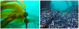
Photo credit: Keith Johnson (bull kelp); Steve Lonhart, NOAA (purple urchins)
Sorry, the comment form is closed at this time.